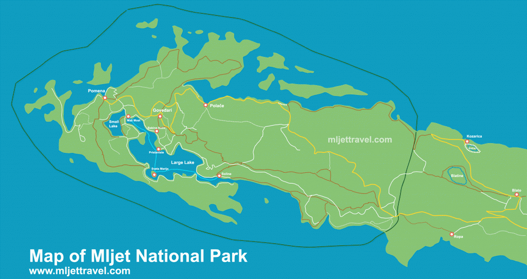
Map of Mljet National Park

Map of Mljet National Park covers the western part of the island (see the green line that indicated the National Park borders) and shows the main points of interest of the Park, including Pomena and Polace ferry ports, the main arrival points, Large and Small lake, Mali most, Sveta Marija Islet, walking and hiking paths around the Park, small roads and lanes (white color) suitable for walking and cycling and the main road (yellow color) where buses are connecting the main places.
The light blue dotted line shows a boat/ferry route in the Park. See also details about getting to Mljet from Split and/or to/from Dubrovnik.
The main entrance to the park is in Pomena. It also features nearby Kozarica, Blato and Ropa with Blatine and Slatina with an unusual, small but deep lake (blue dots in the right corner).
I draw this map tracing several sources. It is a visitors info map with just basic details. If you click on the above image you can see the large one of 3000px. Feel free to download it and keep it for your private use.
Once you arrive on Mljet, you can get a similar one, also very basic with similar info from the local tourist office for free.
If you intend to do some serious hiking in the Park you will definitely need a better, more detailed map. The best one is published by a local mountain rescue service, you can get it from Amazon here